Promenade Information
History
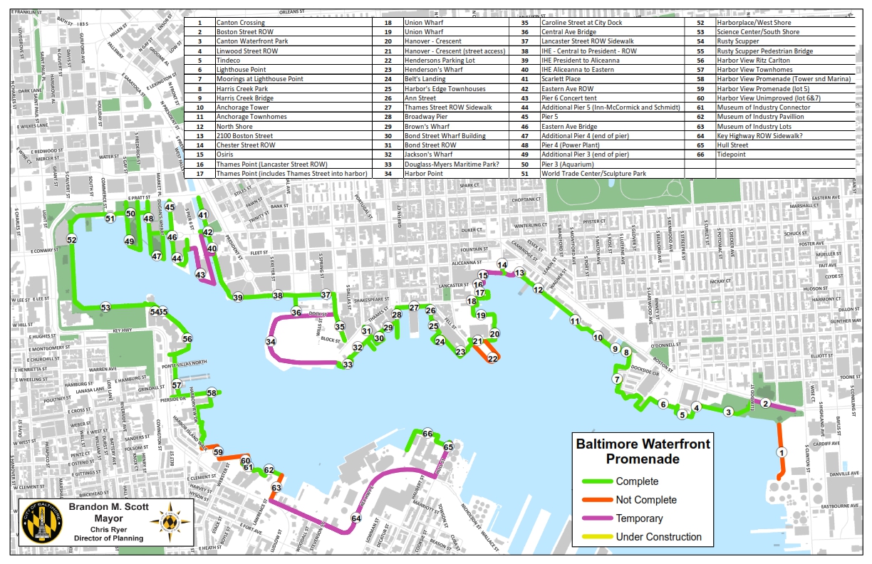
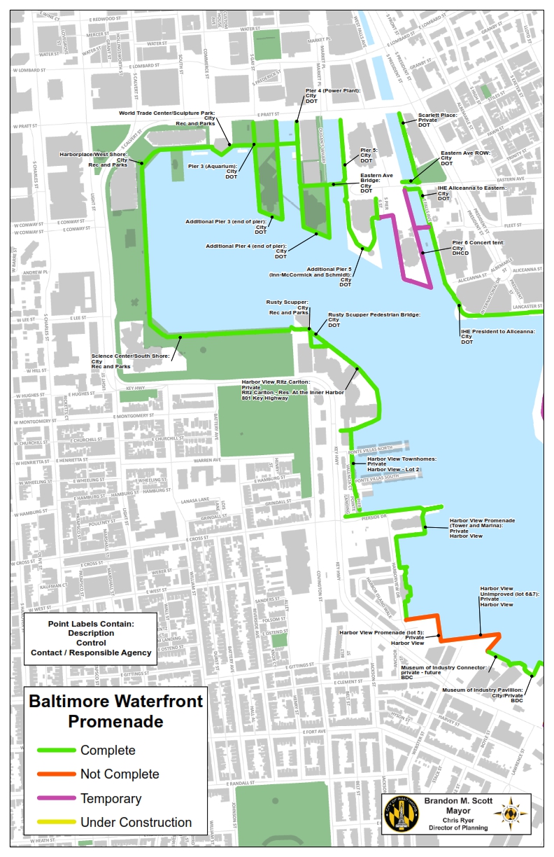
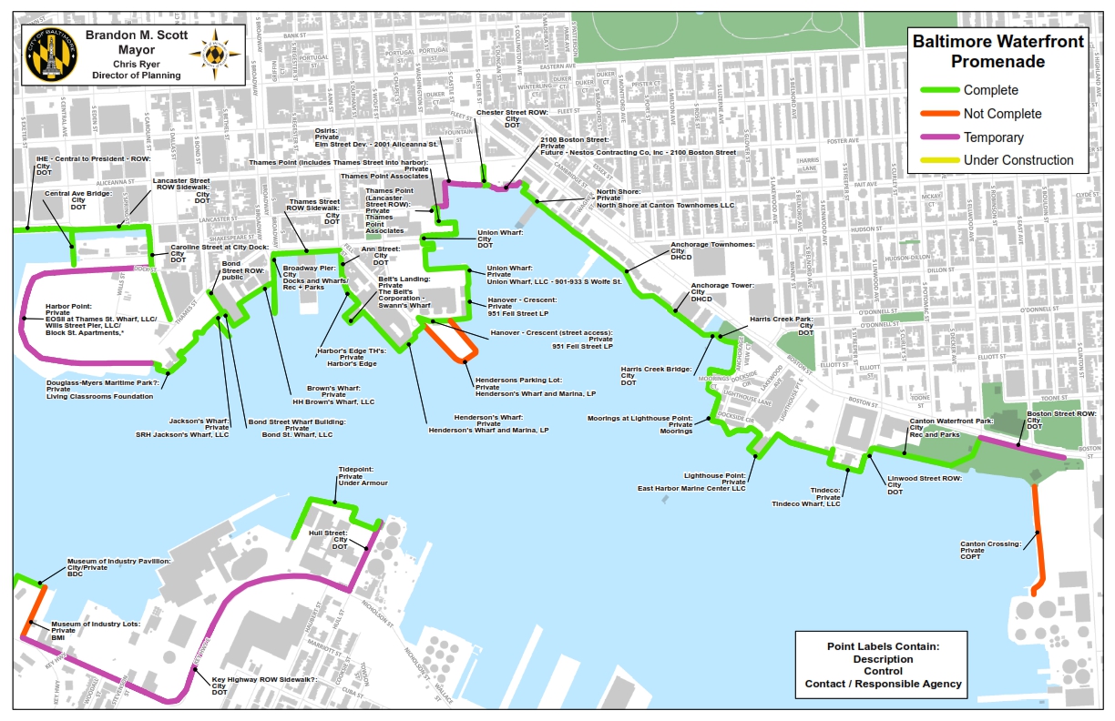
Baltimore’s Waterfront Promenade represents a unique public and private partnership that has ensured public access to the city’s most cherished natural asset – its harbor. It is a public pedestrian walkway/shared use bicycle path that functions as a waterfront sidewalk for development sites and public spaces that have emerged from the former industrial waterfront. The concept of the eight-mile promenade was established in the 1960’s as a key component in the Inner Harbor Master Plan – a visionary plan that proposed massive redevelopment of land adjacent to the historic harbor that was the basis for the founding of Baltimore in 1729.
The current promenade represents a mixture of public and privately owned land. The information on this page will assist in identifying the status of a specific portion or promenade and whether it is owned and managed by the City of Baltimore or a private entity. The following maps provide a quick reference tool to assist in identifying this ownership information. All complete portions that are privately owned have a corresponding Promenade Easement agreement which outlines the public access the responsibilities of each party involved.
Click on the images below to view full map.
Promenade Easement Documents
Existing promenade easements on privately owned land can be clicked on below:
2100 Boston Street
Anchorage Towers
Ann Street Wharf
Belts Landing Condos
Bond Street Wharf
Broadway Pier
Douglas Myers Maritime Park
Harbor East Agreement - Legg Mason/Four Seasons
Harborview Lot 1
Harborview Lot 2
Harborview Tower Lot
Harborview Tower Lot Continued
Henderson's Wharf
Jackson's Wharf
Lighthouse Point
Museum of Industry
North Shore Townhomes
Osiris Property/ Aliceanna Street
Thames Point
Thames Point Apartments
Tide Point/Under Armour Campus
Union Wharf
Ritz Carleton - 801 Key Highway
Scarlett Place
Swann's Wharf
Under Armour Campus Walkway - Port Covington
- Wills Wharf
Promenade Closure Requests
Individual easement agreements provide for a maximum number of promenade closures per year for private use. Those requests will be accessible here:
May 18, 2018 - Under Armour Campus
May 2018 - Harbor Point - Construction Closure - route map
November 2019 - 2001 Aliceanna Street Redevelopment - Construction Closure - Route Map
This information is approximate and full agreements should be read in order to determine detailed information.